The Virginia Triple Crown backpacking trail takes you past three of Virginia’s jewels: Dragon’s Tooth, McAfee’s Knob, and Tinker Cliffs. This three-day, 30-mile loop is moderately difficult but the views are well worth the effort.
Trail facts
- Length: 30 miles
- Duration: 3 days
- Peak Elevation: 3,197 feet
- Best Season to Hike: Spring to Fall (the NOBO AT thru hikers will be coming through April-May)
- Difficulty Level: Moderate
- Beginner-friendly: Maybe; see a beginner-friendly modifications here
- Bear Canisters: Not required
- Permits: Not required
Itinerary
This trek of the Virginia Triple Crowns is a three-day trip starting from the Dragon’s Tooth trailhead. Download the complete itinerary, including mileage, here.
Trailhead parking
The trail begins at the Dragon’s Tooth trailhead, located here.
Additionally, there is a dedicated shuttle with pickups in Catabawa, Salem, and Rt. 311 that drops hikers off at McAfee’s Knob or Dragon’s Tooth. The shuttle schedule is listed here.
This is not a loop trail, meaning you’ll need a car at both the Dragon’s Tooth parking lot and Daleville, VA, or a ride to Dragon’s Tooth.
Day one (11 miles) – Dragon’s Tooth

- Start from the Dragon’s Tooth trailhead, and follow the Dragon’s Tooth trail until you intersect with the Appalachian Trail at Lost Spectacles Gap.
- Following the Appalachian Trail uphill. This section is considered difficult, with some rock scrambles and rock ledges. Continue until you reach the blue-blazed side trail leading to Dragon’s Tooth.
- When you’ve finished exploring Dragon’s Tooth, follow the Appalachian Trail back to the Dragon’s Tooth trail. Instead of turning down Dragon’s Tooth, continue to follow the Appalachian Trail.
- For a thru hiker favorite, take a small .3 road detour at VA 624 to Catawba Grocery on VA 311 for some cold drinks, ice cream, and pizza.
- Follow the Appalachian Trail until you reach the John Springs Shelter. Camp here for the night. If this shelter is full, the Catawba Mountain Shelter is only 1 mile further.
Day two (9 miles) – McAfee’s Knob and Tinker Cliffs

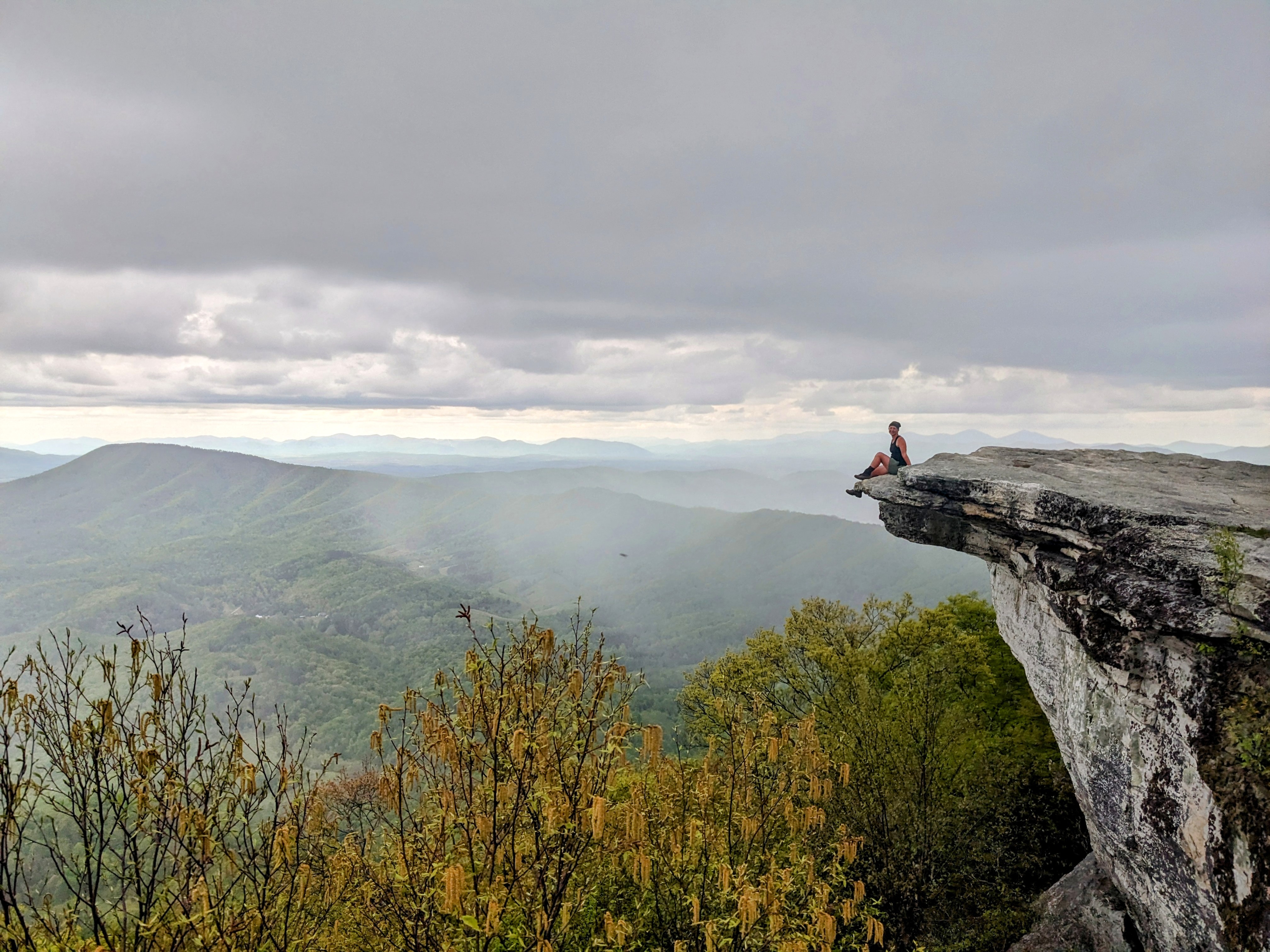
- You’ll begin the day by immediately going into a steady climb up to McAfee’s Knob. The viewpoint is the most photographed spot on the Appalachian Trail. Being only 3 miles from John Springs Shelter, it makes for an excellent sunrise and breakfast spot.
- After enjoying the view, continue along the Appalachian Trail. You’ll pass Campbell Shelter and Pig Farm Campsite where you can refill your water.
- You know you’re close to reaching the end of your mileage for the day when you reach Tinker Cliffs. After you’ve enjoyed the cliffs, continue to Lambert’s Meadow Shelter. Stay there for the night.
Day three (10 miles) – Daleville, Virginia
- Make sure you fill up on water at Lambert’s because there aren’t any reliable water sources until you reach the valley.
- Hike along the Appalachian Trail from Lambert’s Meadow to Daleville. There aren’t scenic outlooks as big as McAfee’s Knob or Tinker Cliffs, but you’ll pass through beautiful scenery and several overlooks of the reservoir.
- The trail will bring you to Roanoke Rd., next to a cleaning company and a gas station. A side trail slightly before you reach the road leads you to the Hay Rock Trailhead (39 Tinker Mountain Rd, Daleville, VA 24083) where you can park your car overnight in Daleville if needed.
- There are several hotels in the area with hiker discounts within walking distance. While you’re in town, treat yourself to some delicious pizza at Bellacino’s Pizzeria only .7 miles up the road.
Water
Water depends heavily on the season you’re in. In the valleys, you’ll have more access to water. However, in the heat of summer and fall, water is scarce on the ridgelines. Take advantage of the water sources you come across.
There’s water sources at each shelter on the AT; however, they have a tendency to go dry in the heat. The Roanoke Appalachian Trail Club provides updates on the water status for the Triple Crown.
Camping
Along the Appalachian Trail from Dragon’s Tooth to Daleville, Virginia, there is no dispersed camping allowed. You may only camp at the designated shelters along the trail. Because of the popularity of the Triple Crown loop, there’s multiple shelters along the way.
You’ll pass both John Springs Shelter and Catawba Mountain Shelter before you reach McAfee’s Knob.
Campbell Shelter and the Pig Farm Campsite is one mile past McAfee’s Knob. The water source can be found by following a blue blaze from either camp area to across the powerline strip.
Lambert’s Meadow Shelter is next to a medium creek and is the most likely to have water, even during the hot summer months. This is the furthest AT shelter you’ll pass.
As always, when camping, follow the principles of Leave No Trace, and do your best to leave the site better when you leave than it was when you found it.
Beginner-friendly backpacking trail
This route is one of my favorite three-day sections to take new hikers on. You will need a car both at the McAfee’s Knob parking lot and the ending Daleville section. Make sure everyone has the gear they need with this comprehensive gear checklist.
McAfee’s Knob to Daleville
Day one (5 miles):
- Start at the McAfee’s Knob parking lot. Note: Through 2024, this parking lot is undergoing construction to enlarge it and add a pedestrian bridge over VA 311. Alternative parking locations can be found on the Roanoke County website. Additionally, there is a dedicated shuttle with pickups in Catabawa, Salem, and Rt. 311, and Dragon’s Tooth that drops hikers off at McAfee’s Knob. The shuttle schedule is listed here.
- After a steady climb, you’ll come to McAfee’s Knob. After enjoying the view, continue another mile to the Campbell Shelter, where you’ll spend the night.
Day two (6 miles):
- Continue along the Appalachian Trail, following the ridgeline’s ups and downs until you reach Tinker Cliffs. Tinker Cliffs has a view comparable to McAfee’s Knobs but with less people. Continue on to Lambert’s Meadow Shelter, and spend the night there.
Day three (10 miles):
- Hike 10 miles along the Appalachian Trail from Lambert’s Meadow to Daleville. Despite the longer distance, the trail is easier than the previous two days. There aren’t scenic outlooks as big as McAfee’s Knob or Tinker Cliffs, but you’ll pass through beautiful scenery and several overlooks of the reservoir.
Virginia Triple Crown Loop variation
If you’d prefer a loop trail, Into the Backcountry has a 3-day, 40-mile loop guide, using the Andy Layne Trail, Catawba Valley Trail, and North Mountain Trail to loop you back to Dragon’s Tooth.
Leave a Reply