The White Mountain National Forest (or the Whites as we hikers refer to them) may very well have won the spot of “most terrifying to NOBO hikers.” Much like ‘Rocksylvania,’ we’ve been hearing about this section of the trail since we’ve begun.
Reportedly, it’s the hardest section of the trail. New Hampshire and the Whites are synonymous with knee pain, mental frustration, and exhausting climbs. “They don’t have switchbacks in New Hampshire,” we were warned. “Everything just goes straight up there. It’s the hardest hiking of your life.”
Experienced thru-hikers would pause there though, their eyes clouding over slightly as they mentally travel back to those trails and peaks. “But it’s the best part of the trail,” they add then. “The most incredible scenery you’ll see on the entire AT.”
Mt. Moosilauke

Mt. Moosilauke was our first mountain to climb in the Whites. Since we’d summited Killington in Vermont, it wasn’t our first 4,000 footer but it was our first venture above the treeline in a long time.
We paced ourselves on the climb, moving at a steady pace up. As we neared the top, I congratulated myself. All this we’d heard about how hard the Whites were and the ascent up Moosilauke wasn’t any harder than the ascent up Killington. Granted, the descent was said to be rougher, but if I could handle going up, surely I’d be able to handle going down.
As we climbed higher, the pine trees shortened, growing narrower and thinner. They huddled together, grasping at each other for support against the wicked wind they could get that high up. Soon I could touch their tops, then they reached my hips, then suddenly, they faded away, exposing us completely and fully to the wind rushing over the bald mountain peak.
The wind snapped at the edges of our rain covers, pushing and pulling at us. I couldn’t help but laugh out loud, though the sound was batted away. It was incredible.
We reached the summit, pausing just long enough to take a picture before heading toward the cover of the trees and the descent. While it wasn’t dangerously windy, it was cold, colder than we’d been in a long time.
I would later find out that the descent down Moosilauke is the second steepest section of the AT (the steepest mile is on the Wildcats, our last day in the Whites).
My cocky confidence going up Moosilauke was quickly shattered as I observed the steep down, the uneven rock steps slick with the rain we’d been having. When the rockface was too steeply straight down, trail maintainers added wooden steps, equally slippery with the wet conditions to walk down. It took me a humbling amount of time to make my way down that descent… and the day wasn’t over yet.
As soon as we reached the trailhead, the AT crossed the road and went straight up another set of uneven rock stairs. As I struggled over what was supposed to be the “easy 2,000 ft” climb between Moosilauke and our shelter, I realized for the first time that perhaps the hype around the Whites was not overdone. Maybe they were, truly, really, really hard.
I sprawled out on the shelter floor when I arrived. Bear looked over at me. “That was a rough day, huh?” I had just the energy to nod at him. Shaggy and Ice Noodle, doing the same 17 miles we did, straggled in an hour after us. “What was that?” Ice Noodle gasped.
“Welcome to the Whites,” said the SOBOs (southbound thru hikers) also sharing the shelter with us.
The Kinsmans

The next day, we hiked over the two Kinsman peaks. They were the most technical of our climbs, as in tucking away my trekking poles and scrambling up the rocks using my feet and hands. And yet, despite the weariness we had yesterday, they were delightfully fun.

Plus, there were two ponds that day. One we ate lunch by, and the second one, next to a hut, had a dock where Stealth went swimming.
After coming off of the Kinsmans, we headed into town for a shower at the Old Colony Ski Club and a restock. As we looked at weather, it appeared we’d have bad weather both for going over the exposed Franconia Ridge and Mt. Washington. Thus, we made the call to stay in town and hope to get better weather lined up for those two areas.
Franconia Ridge

Our zero day in town worked. As we restocked in the valley, we could see the clouds enveloping the ridgelines above us. That night, it thundered hard enough to shake the house and I watched bolts of lightning splinter across the sky.
The next morning, we headed out for Franconia Ridge. There were still thunderstorms in the forecast, but not until the afternoon and we were confident we had enough time to get to our shelter for the night before they rolled in.
Despite the imposing height from the ground, the climb up to the ridgeline was steady and smooth. We kept our heads tucked down, focusing on each footstep, and before we knew it, we were above the treeline once again.

Despite the cloudy skies listed in the forecast, it was brilliantly blue. There were a few clouds hugging the valleys, but on the ridgeline we had a view across the entire mountain range. I could follow the trail, its rocky ups and downs across the different peaks, from Lincoln to Lafayette.
We met Soup Cup there, also wandering among the beautiful scenery. “This,” he said, echoing all of our thoughts, “this is what I’m here for.”
When we reached Lafayette, the tallest peak on the Franconia Ridge, the promised rain clouds began to gather. We ate a small lunch of protein bars and continued on, descending below the treeline and making one more climb up to Mt. Garfield before making it to our camp. Amazingly, we didn’t get wet at all.
The Presidential Traverse and Mt. Washington

We broke the hike through the Presidential Traverse into two days. There were thunderstorms forecasted for the afternoon of first day and we didn’t want to be up in the exposed ridgeline after 2 pm. With that, our plan was to hike just above the treeline to Lake of the Clouds hut on Sunday and then, when the weather was supposed to be clear, hike over Mt. Washington and finish the Presidential Traverse on Monday.
We woke up on Sunday to rain. Well, perhaps I should say, it woke us up. Twice in the night there was a downpour that exposed a leak in the shelter roof just over my mat. Thankfully the shelter had just enough space left I could shift away from the leak until the downpour ceased.
It was overcast but not raining when we left the shelter. That only lasted about fifteen minutes, though, before the sky darkened even further and started spitting raindrops. It didn’t take long for us to become drenched, slogging down the trail as the water ran down our faces, off our backpack rain covers, and down our legs into our shoes. This is gonna be a long day.
We hiked in silence, finishing the downhill, crossing the river on a bridge (thankfully; otherwise I was worried it would have swollen with the recent rains), and then heading up the sharp uphill towards the Presidential ridge. Neither I nor Stealth spoke, focusing only on each sloshing footstep, heads bent, breathing rhythmic.
Then came Webster Cliffs. The rain had become a drizzle by then, but still there was water rolling down the rocky path like a stream. The rocks were slick in the water and yet the path stretched up a slanted rock scramble. We aren’t going along the cliffs, I realized. We were going up the cliffs.
It slowed us down quite a bit, and we reached the next hut later than we thought. We met Jukebox there, a fellow hiker we’d been bouncing back and forth with, who was staying at the campsite as a zero waiting for the weather to clear before heading up into the treeless traverse. She invited us to stay with her, but a chat with the hut croo informed us that we should be able to make it to Lake of the Clouds before the bad weather rolled in.

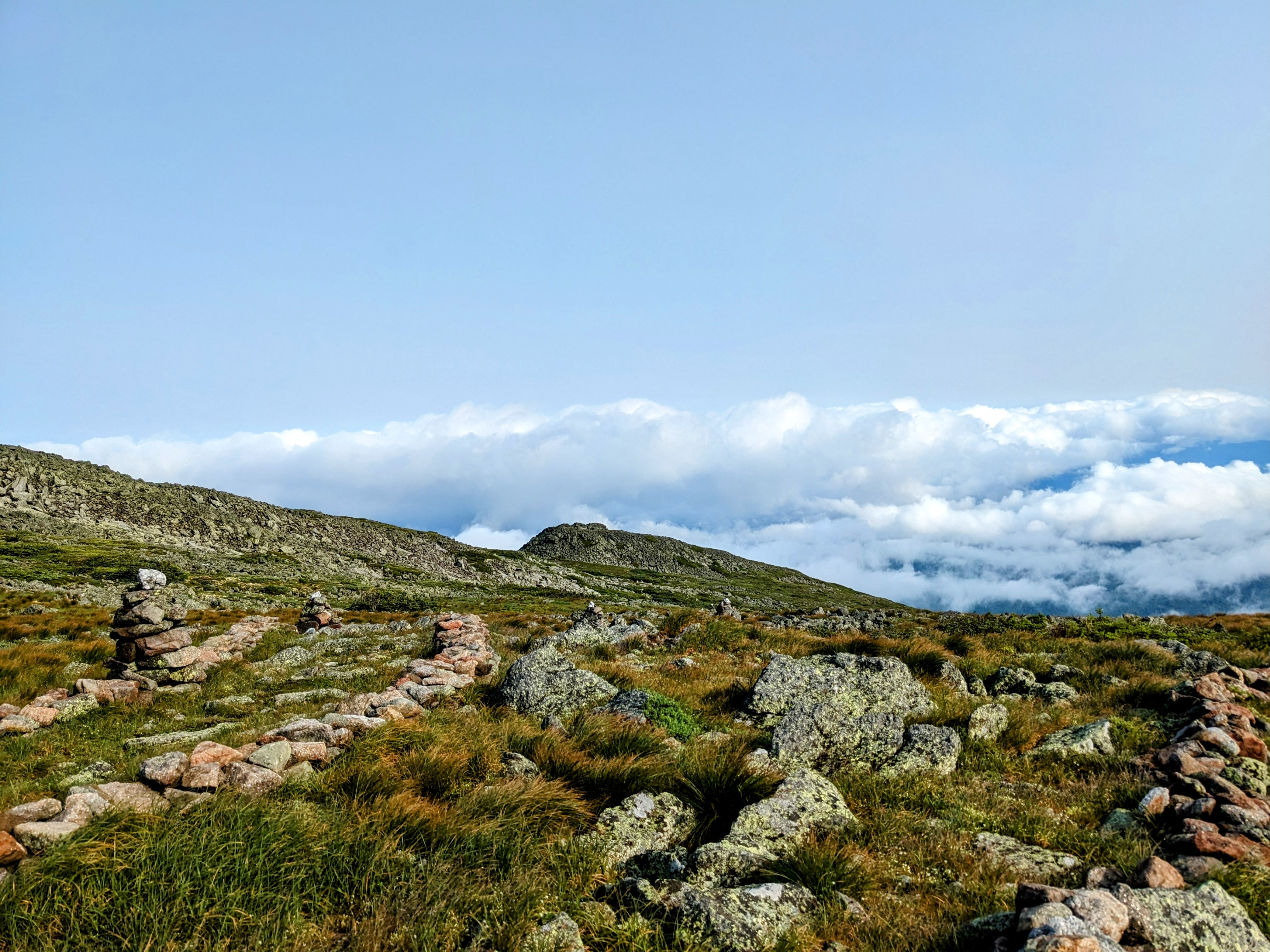
It was an eerie walk through the traverse. The path was marked on both sides by a small wall of stones. Fog was so thick you could barely see from stone cairn to stone cairn. The wind buffeted us sporadically, massive gusts of wind that could catch you and throw you off balance if it caught you unaware. We saw only one other group of hikers coming down from the hut. “It’s windy up there,” one of them said to us, but those were the only words exchanged.
Despite the otherworldly terrain, the elevation change was easy on this section of the trail. We walked in the shadow of two of the Presidential mountains as we headed towards Mt. Washington and after the technical hike up the cliffs earlier, it was an easy stroll to the hut.
We stayed in the dungeon there, a basement bunkhouse provided to thru-hikers for $10. During the winter when the hut is shut down, it serves as an emergency shelter. It’s easy to see why it got the name “dungeon.” It’s only accessible from the outside of the hut, barricaded behind a sturdy metal door that screeched when you opened it. The bunks on the bottom were wet and the entire room smelled of mildew. Yet, the middle bunks were dry, it was warmer than outside, and it was a safe spot to be during the forecasted thunderstorm (which actually never even came).

The clouds and rain were forecasted to move out in the night, which gave us hope for a sunrise from the summit of Mt. Washington. At 3 am, we cautiously peeked our heads outside. It was clear! We packed up our things and slipped on our packs, but by the time we started up the mountain at 3:30, another layer of clouds had rolled in.
Oh well, we thought. We’re already up. We hiked the remaining 1.5 miles to the summit of the mountain, making it there in time for a hidden sunrise and the viciously cold bursts of wind Washington is famous for.
When our surroundings began to naturally lighten, even though the sun would remain invisible to us until about 8, we started our trek down from Washington across the Presidential Traverse towards Mt. Madison.
The Traverse, entirely above treeline, is a rockfield. It’s slow to walk across, each foot needing to be placed with care to avoid slipping, sliding, or falling. I, of course, did plenty of all of those things, making it to the end of the traverse with a couple new bruises. And yet, despite the annoyance of the unpredictable rocks, it was incredibly beautiful.

As the sun burned away the fog, the rocks lit up like glitter, shimmering under the bright rays. The hardy green plants fighting for life in the spaces between the boulders glowed radiantly. Clouds floated in the blue sky below us and above us, and the rising mountains and rolling stretches of boulders stood regally against the horizon. It was sad when we finally dropped below treeline again and had to leave the remarkable landscape behind.
That night, we spent the night in the overflow parking lot at Pinkham Notch. We laid all our wet gear out in the sun to dry out and got food and a shower in the visitor center. That night, sore, tired, and thankfully dry in my tent beneath a clear sky, I folded up my jacket as I always do for my pillow that night. Suddenly, I stared at it, a weary annoyance filling me. “I miss my pillow,” I finally said out loud.
It’s the first time I believe I was ready: ready for Maine, ready for Katahdin, ready for four walls and a roof and the simple luxuries of civilization, ready to mark this journey as “finished.”
But not yet: the Whites weren’t finished yet, and there’s still Maine to hike through. And despite my weariness, I’m still
The Wildcats and the Carters

The night before, at the visitor center, we learned that our first ascent today would be the steepest mile on the entire trail. We’d already done some pretty steep ascents, and I wasn’t sure how much steeper it could get. Thunderstorms were again in the forecast for the afternoon, and we had 11 miles to get done before they rolled in. There was no point in delaying it, so up we went.
We took it steady and surely, pausing at the outlooks to admire how high we’d come in such a short distance. Before we knew it, we were at the top of the Wildcats. When we reached our last hut, nestled 5 miles from Pinkham Notch in a deep gully between the Wildcats and Carter Mountain, we discovered it’d taken us nearly five hours to go those five miles, the hard ups and downs bringing us down to one of our slowest paces yet.
We paused for a moment at the hut to eat some leftovers, and then had a steep, stone-stair climb out of the notch up to Carter’s Dome. This climb was harder for me than the steepest mile, the continuing after I was already tired.
As we hiked along bog bridges crossing an alpine bog, the dark sky suddenly rumbled in the distance. A thunderstorm. We both looked at each other and instantly picked up the pace. We wanted to be off the ridgeline as quickly as possible.
The thunder moved closer, and then right over top of us just as we made it to where the trail dropped back into the treeline. Dropped, I say, because it felt like a literal drop. The trail wove its way down over rock scrambles, steep piles of rocks, and granite slabs. We hurried as we could but the rocks were wet and we had to be careful.
Just as we reached the shelter, the thunder faded and the sun poked its way out of the clouds. We managed to get a shelter spot and caught up with some old friends.
The next day would be a zero for us, a reward we promised ourselves for making it through the Whites. The little town of Gorham had a well-known hostel and several good spaces to rest, recover, and let our bodies heal.
Entering Maine

The trail across the Whites counts as the entirety of the AT in New Hampshire. After coming down off of Carter Mountain, there were a couple more mountains to cross, and then, the border to Maine.
We have officially hiked through 13 states; now there’s only one remaining. It’s a very bittersweet feeling. I’m not ready for the idea of this hike to end, to go back to normal life, to reenter civilization, to leave my mountains behind. On the same note, my knees crack with the consistency of a percussion instrument, my gear is slowly shredding, and I miss simple luxuries like a pillow, dry clothing and shoes, and being able to stay inside when it’s raining.
We’re so close to Katahdin, and yet so far. But these miles are going to tick by quickly and before I know it, my hike will be completed.
Hello Maine. I’m excited for you.
Leave a Reply